Route Map W/ Bikemap.net
by camirrakiu in Circuits > Assistive Tech
1851 Views, 5 Favorites, 0 Comments
Route Map W/ Bikemap.net

(i wrote this entry originally to the EntreRayos site... in spanish, in this instructable i'll put two versions: the original (spanish) and the translated (with the robotical google-translater).
 En más de una ocasión hemos querido planear con antelación un paseo en bicicleta, nos gustaría saber cual es el recorrido más óptimo y tener noción sobre como es el relieve que recorreremos. En algún momento hubo que confiar en lo que algún amigo nos comentara de la ruta o, si nadie la conocía, ser uno mismo el descubridor y arrojarse a la pista sin conocer nada… pero esos días acabaron. Hoy les hablaré sobre una aplicación online que nos permitirá trazar recorridos y obtener información sobre nuestra ruta, para que los paseos sean espléndidos y no tengamos sorpresas desagradables. Hoy aprenderemos a usar Bikemap.
---
On more than one occasion we wanted to plan ahead for a bike ride, we would like to know what the most optimal route and have idea on how is the relief that we cover. At some point had to trust what a friend we comment on the route or, if no one knew her, be yourself and throw the discoverer to the track without knowing anything ... but those days are over. Today I will talk about an online application that will allow us to draw routes and information on our route, so that the walks are splendid and have no unpleasant surprises. Today we will learn to use Bikemap.
Registro
Lo primero de todo es entrar al sitio de bikemap y…

…fijarnos en la esquina superior-derecha, donde tenemos que hacer click en Registrarse, también se puede entrar usando la cuenta de facebook, pero hay varios motivos para no sugerirlo como opción, así que sigamos. Hacemos click en Registrarse y…

…llenaremos el formulario con nuestros datos, pronto nos llegará un correo con un link para confirmar el registro, al que hacemos click y ya estaremos con todo listo, así que ahora entramos nuevamente al sitio de bikemap y buscamos los siguientes botones: Crear una ruta o Buscar una ruta. Desde luego, que clickamos en Crear una ruta.

---
The first thing is to enter the site Bikemap and ...

... Look at the upper-right corner, where we have to click on Register, you can also log in using facebook account, but there are several reasons for not suggest it as an option, so we continue. We click on Register and ...

... Fill the form with our data, we soon reach an email with a link to confirm registration, which we click and we'll be all ready, so now we go back to the site and look Bikemap the buttons below Create a route or Search a route. Of course, click on Create a route.

Mapeo 1

Veremos algo parecido a la imagen de abajo, que es una adaptación de los mapas de Google, con la funcionalidad de trazar recorridos sobre ellos.

Bajo el cuadro de búsqueda de ciudades, aparecen tres opciones…

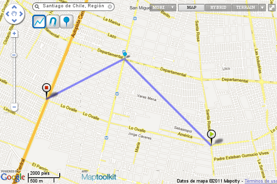
La primera es para hacer recorridos lineales, es decir, marcando uno mismo punto a punto el avance del camino. En la imagen de abajo, vemos como funciona esta modalidad. Claro que, no nos sirve para recorridos de más de una cuadra, porque el punto-a-punto no reconoce esquinas ni cuadras y nos sugiere pasar por el techo con nuestra bicicleta.

---
We will see something like the image below, which is an adaptation of Google maps, with the functionality of mapping around on them.

Under the search box of cities, there are three options ...

The first is to make linear paths, ie, setting a same point to point the advancement of the road. In the picture below, we see how this method works. Of course, not useful for runs of more than one block, because the point-to-point does not recognize corners or blocks and suggests going through the roof with our bike.

Mapeo 2

Así que, mejor usemos la opción de trazado con imán.

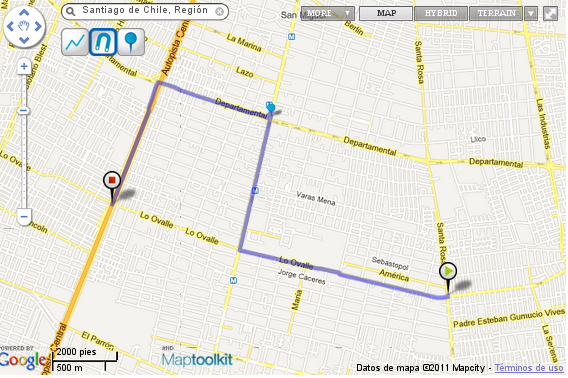
Ahora, al marcar sólo tres puntos, el sistema reconoce que queremos ir de uno a otro y que somos seres materiales en un universo material y tenemos que movernos por las calles habilitadas. El problema de esta opción (el trazado con imán) es que no siempre hace las rutas más óptimas que, en el caso expuesto, sería tratar de avanzar en diagonal doblando cada una cuadra para llegar de un punto a otro… así que, en esas ocasiones quizá es mejor darse el trabajo de hacer el marcado punto a punto de la ruta, para obtener un mejor resultado.

---
So better use the magnet layout option.

Now, selecting only three points, the system recognizes that we want to go from one to another and that we are material beings in a material universe and we have to move through the streets enabled. The problem with this option (the layout with magnet) is that it does not always make the best routes, in the case above, it would try to move diagonally doubling each block to get from one point to another ... so, in those sometimes maybe it's better to take the trouble to make the marking point to point along the route, to get a better result.

Poner Info
Una vez habiendo terminado la ruta (que, por supuesto, puede tener más de tres puntos, como la del ejemplo), nos queda llenar el formulario con información de ésta. Está todo en castellano y no creo que merezca mayor explicación este paso… vamos, es solo leer y contestar.

Cuando esté listo esto, hacemos click en Guardar y esperamos un poquito… hasta que cargue la página siguiente…
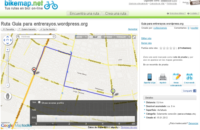
Cargará la página con nuestra ruta trazada. A la derecha se ve la información que le entregamos y cuatro botones: Exportar a GPS (que nos permite bajar un archivo para GPS o Google Earth), Imprimir, Nuevo entrenamiento (que agrega el recorrido a una agenda que bikemap nos da) y Crear evento (para invitar a los amigos a unirse y pedalear en grupo).

En cuanto al mapa, veremos que en la parte inferior izquierda de éste, hay un gráfico que antes no estaba: es el gráfico de alturas que nos muestra la pendiente que tiene nuestro recorrido. No hay que perder de vista que este gráfico está en escala así que, en los recorridos largos que tracemos, no hay que temer a las pendientes que se vean muy fuertes, porque en el mundo real quizá sean sólo una subida constante de 20 ó 30 kms que no significará mayor problema.
Espero que les sirva este mini manual… hasta el momento, siento que no me quedaron cosas en el tintero, pero si existiese alguna duda, déjala en los comentarios.
---
After having finished the route (which, of course, can have more than three points, as the example), we still fill the form with this information. It's all in Castilian and I do not deserve further explanation this way ... come on, it just read and answer.

When you are ready this, we click on Save and wait a bit ... until you load the next page ...
Load the page with our planned route. To the right is the information we deliver and four buttons: Export to GPS (that allows us to download a file for GPS or Google Earth), Print, New training (which adds the path to an agenda that gives Bikemap) and Creating event (to invite friends to join the group and bike).

As for the map, we see that at the bottom left of it, a graphic that was not previously: the graph shows the heights that slope is our journey. Do not forget that this graph is scaled so that in the long runs that we draw, we should not fear the slopes that look very strong, because in the real world may be only a steady rise 20 to 30 kms which will mean greater problem.
I hope you learn this quick tutorial ... so far, I feel that I left things in the pipeline, but if there is any doubt, leave it in the comments.